This is one of four cycle route consultations that Birmingham City Council are holding during November 2021, most of which are improving on routes introduced as pop-up cycle routes during 2020. The consultations all finish on 30th November 2021, and the link to this one is here. Please respond to it and make your opinion as a cycle user known (you can just say that you agree with Push Bikes' opinion), otherwise the council will just receive responses from entitled car drivers.
Push Bikes has previously reviewed the route.
Overview of this Route
This route goes from the junction of Newhall Street and Graham Street in the Jewellery Quarter, across the ring road at Hingeston Street. Then it goes through a housing estate, joining Dudley Road at the canal bridge, linking to where the Dudley Road cycle route will run in the future.
For much of the route, it is segregated from motor traffic, but there are sections on quieter streets where cycle users will be on the general carriageway.
Our Verdict
Overall, this is a reasonable route which provides comfortable cycle infrastructure to go from Dudley Road to the city centre. However, the junction with the ring road will needs more work to bring it up to the same standard as the rest of the route. Also, the route ends at the top of Newhall Street, leaving cycle users cycling with general motor traffic on quite a busy street, so this will need improvements in the near future to make the route popular.
With those caveats, we support this route and think it is a good addition to the cycle network in Birmingham.
Detailed Comments
At most of the bus stops along this route, the chosen solution is for the cycle track to go up on a platform, which bus passengers will use for getting on and off the bus. The route is not going along the busiest bus routes, so there will not be much chance of meeting a bus at those bus stops, but cycle users will need to be careful going past buses when they are pulled up at the bus stops. It is not an ideal solution, but safer overall than letting buses pull into a cycle lane and expecting cycle users to swing out around a bus to get past. It is important, though, that the angles at either end of the bus stop are relatively shallow, so that it is comfortable for cycle users to go up and down. Also it would be better if informal markings (such as diamonds in the same colour as the rest of the route) were added at bus stops to guide cycle users to the back of the pavement, where conflict with bus passengers is less likely.
Graham Street and Legge Lane
On both these streets, there is a cycle lane for people headed out of the city, but those going into the city will be cycling with general motor traffic. On Legge Lane, which is a quiet street, that will be ok, but Graham Street is busier, so it will not be an attractive option for people we hope to encourage to cycle more. Cycling conditions there will need improving later - either reducing motor traffic levels further or finding a way to provide segregated space for cycling.
Dayus Square and Carver Street
The plans show that there is a section of shared-use pavement at the top of Carver Street - we think that is inappropriate as the goal of the changes to the city centre is to get more people walking and cycling. That pavement could be much busier with people walking in the future, and both pedestrians and cyclists dislike the conflict shared-use creates. Also it creates two-tier infrastructure, with some people staying on the carriageway and some using the shared-use pavement. This confuses other road users, who don't understand why people on bikes opt for different paths through the junction. Instead we think that the final narrow stretch of Carver Street should have the parking spaces removed to provide space for the bidirectional cycle track to continue up to Dayus Square, where cycle users can cycle on the carriageway with the minimal motor traffic (there are local traffic restrictions). We don't think that it is appropriate to retain parking spaces but put cycle users onto a shared-use pavement.
Junction with Middleway Ring Road (Icknield Street)
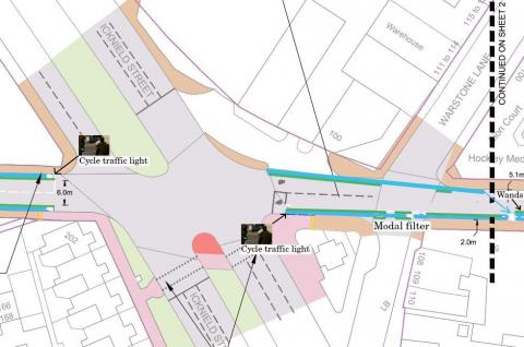
 This is the worst part of the route and will put off some people from using it. The proposed solution of providing shared use pavements and toucan crossings will be very slow and awkward; it's not even clear how people heading in the direction of Carver Street will get to the crossing. More confident cycle users will remain on the carriageway, so we will have two-tier cycle infrastructure here, with on-lookers confused as to why some people are cycling on the pavement and others on the road. It would be far better if the route more confident cycle users will take were formalised and made safe. So rather than creating a toucan crossing, there should be two protected unidirectional cycleways either side of the road between Icknield Street and Carver Street. People heading towards Carver Street can then take advantage of the one-way traffic on Carver Street to cut across to the cycleway (wands would make it easier to rejoin the cycleway late, if someone finds they have trailing motor traffic). Better still, low level cycle traffic lights should be provided at the main part of the junction to give cycle users at least an advanced start over the motor traffic, or preferably a cycles-only phase. Finally, there is a problem with drivers on Warstone Lane heading for Icknield Street not expecting contraflow cycle users coming from Carver Street, so there needs to be filtered permeability on the stub of Warstone Lane between Carver Street and Icknield Street. This is commensurate with the good practice of eliminating uncontrolled crossroads, which have far more points of conflict than a T junction and are therefore far more dangerous for all road users. You can click on the image to see our proposals more clearly.
Hingeston Street
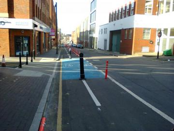
The unidirectional cycle tracks here are quite narrow and get filled up with dead leaves in autumn. It’s important that there are gaps in the segregation units so that cycle users can move between the cycle track and the general carriageway - to avoid obstructions and to overtake other cycle users if necessary. Segregation with wands seems to have worked quite well here, so there shouldn’t be any need for more substantial segregation measures. However, the protected lanes should be taken right up to the existing Hingeston Street / Kingstone Avenue cycle junction, rather than creating an awkward stub of shared-use pavement.
There is a footpath between the end of Ellen Street and Hingeston Street - it would be good to install a dropped kerb at that point, and make the footpath shared use, to enable people in the housing estate to access Hingeston Street more easily by cycle.
Kingstone Avenue and Capstone Avenue
There is no segregation on these residential streets, as is appropriate for an area with low levels of motor traffic.
Clissold Street and link to Dudley Road
The bidirectional cycle track on Clissold Street was in the original pop-up cycle route, but the conversion of the access road through the park to a bi-directional cycle track with a pavement alongside is new. Most of the width is provided by the existing access road, but a little bit of grass will be lost to get a consistent width along the whole length. There should be dropped kerbs provided at the canal access points so that cycle users can get on to the canal towpath.


