
Sustrans were given the brief of exploring improvement of the public realm on Kings Heath high street. This is a proposal for how cycle lanes might be fitted in, drawn up by Push Bikes members in December 2014.
The objective of the Push Bikes proposal is to to make it a more pleasant environment for shopping and socialising. Since people still need to make door-to-door journeys and there is a strong demand for cycling in Kings Heath, this should be accomplished by creating cycle lanes that will connect with Highbury Park and the Birmingham Cycle Revolution route along the Alcester Road. Experience from abroad shows that it is relatively easy to achieve urban cycling rates of around 20% if a close-meshed network of usable cycling infrastructure is built (the Dutch have achieved far more). Of course this does take time, but if excuses are found not to build infrastructure at every opportunity, that will never be achieved. As substantial a remodelling of Kings Heath high street as that proposed by Sustrans is such an opportunity.

Towns and cities that replace private car traffic with non-motorised traffic typically see a rise in trade. New Street saw a rise in trade of 25% when it was converted from a busy through-route to a pedestrian zone. North American cities report a rise in trade when cycle lanes are built. New York, for example, saw a 49% increase in trade in the East Village when protected cycle lanes were put in place. Despite that, businesses consistently underestimate how many customers arrive by bike, and overestimate how many arrive by car. Shops in the cycling countries of continental Europe on the other hand are well aware of the benefit of cycle traffic to their business, and take care to maintain it and ensure cyclists have somewhere outside their shops to park their bikes. The rise in trade comes about because it is easy for a cyclist to stop outside a shop and make purchase, whereas a car driver will have to search for a free parking bay, which may be so far down the street that they just give up and drive on. Cars require a lot of space for parking, so it is inevitable that there could only ever be a small number of parking bays on the high street.
In addition to reducing motorised traffic, cycle lanes create a safe buffer from motorised traffic for pedestrians. They also reduce conflict on the pavement, because there will be no need for either cyclists or electric scooter users to use the pavement.
Whilst imposing a 20mph speed limit on the High Street is wise (the arguments for this now being well known), in heavy traffic (which is typically slow-moving anyway) it does not make cycling any more pleasant or acceptable to the majority of the population. It is important to understand that survey after survey has concluded that most people will not under any circumstances consider using a bike if it requires cycling in fast or heavy traffic. Do nothing to address that, and the congestion in Kings Heath will remain for the foreseeable future, because people will only consider the car a safe form of personal transport. That congestion makes Kings Heath High Street an awful environment for shopping and socialising.
After consulting with Adrian Lord, consultant to the Birmingham Cycle Revolution, the carriageway has been made 7.2m wide except in a few locations which will be referred to in the notes for each section of the plan. The cycle lanes have been made just over 1.8m (to allow for wands), reduced to 1.69m where necessary. The narrower sections are coloured on the plans orange instead of red. These widths may need further refinement. As far as possible pavement widths have not been reduced, though some islands at the end of the current parking bays will be removed. It is recognised that pedestrians would like the pavements to be wider, but part of the reason for that will be because no-one likes to be immediately adjacent to motorised traffic. However, there is a big problem with clutter (such as A-boards) on the existing pavement space, which needs to be removed. Sustrans have proposed planting trees along the length of the high street, which would certainly improve the high street environment. In a few places there are some mature trees, planted originally as street furniture. These have grown far too large for the high street, and given their age it would be wise to plant new trees to provide more space for pedestrians, to provide a consistent appearance with the new trees, and to avoid damage to the remodelled street if the old trees are declared unsafe some time in the next few years. However, the trees do not need to be removed to provide space for the cycleways proposed by Push Bikes.
Cycle parking would be mainly on side streets, but on wider sections of pavements it could added as a permeable fence of Sheffield stands along one edge of the footway. It is envisaged that at peak times for pedestrian traffic (typically Saturdays) the cycle lanes may be encroached by pedestrians, but the use of light segregation means cyclists can slow down or pause, or they can switch to the motorised traffic lane if they have the confidence to do so. In practice fast cyclists tend to have the confidence and ability to ride in motorised traffic, and would be happy with this compromise. Whilst this arrangement is not ideal, it should be seen as a transition to a radical redesign of the high street as can be seen in some Dutch towns. A radical treatment such as this would also allow the re-introduction of some features removed to make space for the interim arrangement.
Junctions should be given the Dutch treatment. This means radii reduced to the minimum, carriageway realignment to make the side road join the major road at as close to 90° as possible, cycle lanes and footways carried across junctions clearly and boldly (using red paving), and tables used to additionally slow vehicles. Use of side roads will be restricted by various means to prevent rat-running, making junctions less hazardous and the roads quieter for residents. Cyclists and pedestrians will not be affected by these restrictions, so the reduced traffic loading will make these roads intrinsically suitable for light transport. This technique is commonly used in the Netherlands for these reasons. Below is one possibility:

The red lines indicate main (bidirectional) through-routes. Where a road has no colour, it remains as it is now. The arrows indicate roads that are one-way for motorised vehicles but two-way for cyclists. The different colours indicate the separated sub-nets. The purple lines indicate where a road has been blocked with a barrier that is permeable to cyclists and pedestrians but not motor vehicles (typically using bollards, as they are quick and cheap, but additional features such as planters and emergency access gates are also a possibility). Some of these barriers run diagonally across a cross-roads.
On-street car parking has been removed from the high street. It represents a tiny proportion of the car parking available in Kings Heath, and increases congestion as drivers pull in and out of spaces. Some drivers attempt to reduce the time spent manoeuvring by bumping up the kerb on to the pavement, which is a serious safety issue.
 Pedestrian crossings would be more numerous and would be mainly zebra crossings. Puffin crossings, with their long delays, are so infuriating for pedestrians that pedestrians will often cross on red, leading to occasional injury, but controlled crossings are needed in places for people who as a result of a disability cannot otherwise cross the road. Informal crossings have been found to be largely useless; pedestrians in Haren, in the Netherlands, (also a town centre on a radial route) complained that they were unable to cross the road “informally” and zebra crossings had to be retrofitted.
Technically the best option for bus stops is to have the bus shelter on an island. This is certainly possible in at least one location, but in other locations it would probably result in an excessively narrow pavement. There are two less desirable options. One is to have the bus pull into the cycle lane, but most people dislike sharing space with something as large and heavy as a bus. Also bus drivers are notorious for half overtaking cyclists and pulling into a bus stop, an offensive and highly dangerous practice. The arrangement does have the advantage that confident cyclists can go around the bus on the offside.  The alternative (shown right) is for buses to stop in the main running lane, not the cycle lane. Pedestrians would access the bus via a raised table, which would both allow wheelchair access and act as a speed table for cyclists. Whilst cyclists would probably have to wait for buses to load and unload rather than passing on the offside (though in practice passengers may well let a solitary cyclist pass), once the doors have shut the lane would become clear again. Of course it is often the case that the doors shut but the traffic ahead of the bus hasn't moved anywhere, so the cycle lane would allow cyclists to proceed, whereas at the moment they just get stuck behind a bus. This arrangement has the additional advantage that since shelters would no longer be adjacent to the bus (because of the interposed cycle lane), they could be moved right to the edge of the pavement, recovering about 0.5m of footway for pedestrians. It would be wise to consult with bus operators to see if the bus stops are in the best locations, both in terms of service requirements, and in terms of available space.
All this is based on a carriageway width of 7.2m, which in turn is based on the width needed for one bus to pass another bus at a bus stop. There is a possibility that this could be reduced, in which case there would be more space for the footway, or larger islands at bus stops. It is however beneficial to have space in the centre of the road to aid informal crossing by pedestrians. One possibility is to vary the width allocation along the high street, biasing it first to one side and then to the other. This will create a meander, which will encourage people to drive more slowly. Something that non-locals tend not to appreciate is that at off-peak times speeding on the high street is a problem. Fast-moving trucks are particularly frightening. It is unlikely that visual treatments and / or the 20mph speed limit would address this sufficiently, but motorists are slowed by chicanes. This is why chicanes are a prominent feature of continental roads.
Scale Plans
The plans below are to scale and based on technical drawings supplied by Birmingham City Council. The carriageway area is shown in blue, and is 7.2m (bidirectional). The unidirectional cycleways vary between just under 1.7m (orange) and 1.8m (red).

The blue lines at the junction with Queensbridge Road show traffic movements and are sized according to the running lanes on the high street. This is purely for graphical completeness, and should not be regarded as meaning that the junction area is replaced with narrow, discrete lanes.
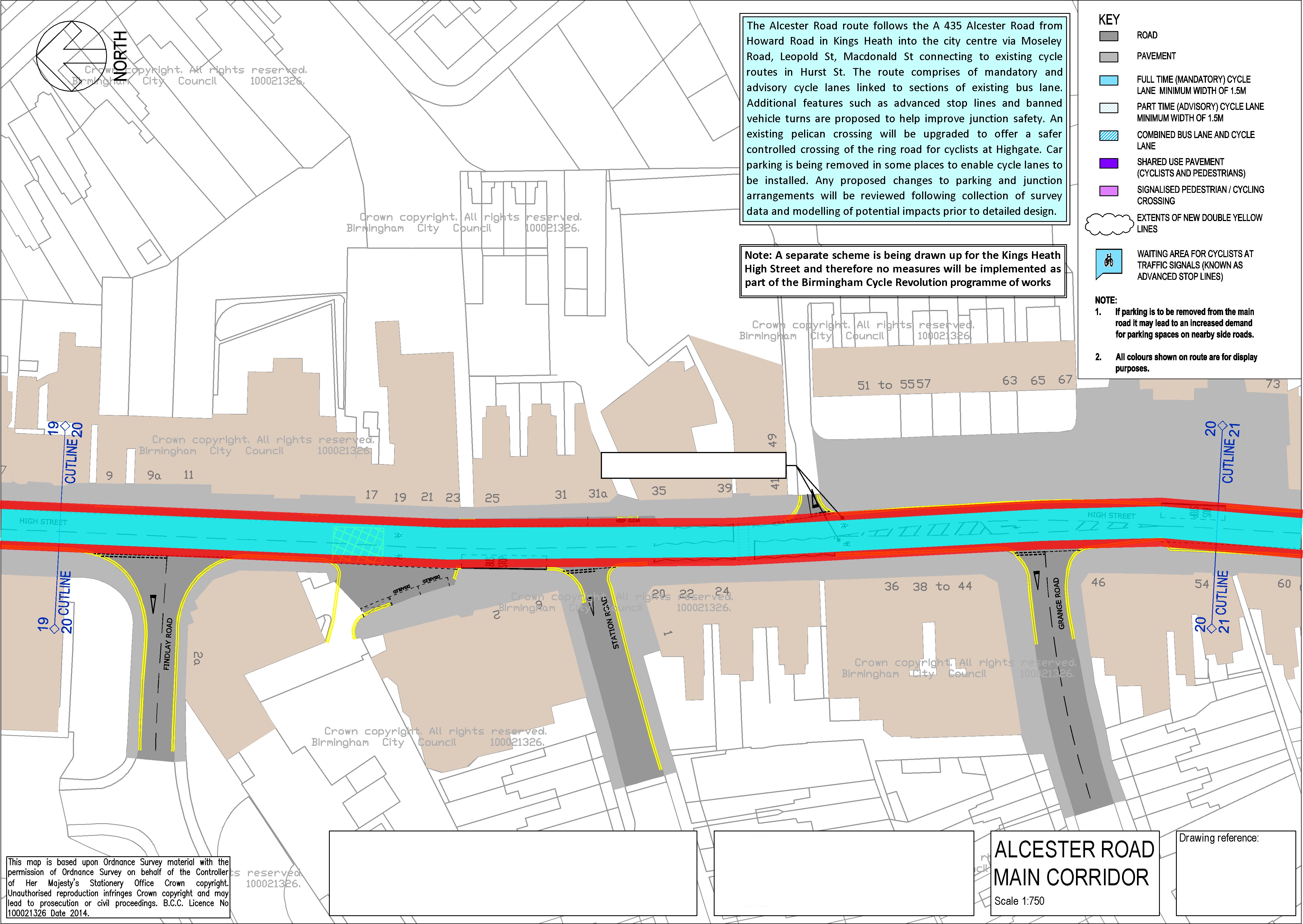
There is scope here for providing a proper island bus stop southbound, as there is an enormous amount of space here, much of it completely unused.
The right-turn pocket into Grange Road has been removed. If this creates traffic flow problems, the right turn should be prohibited.
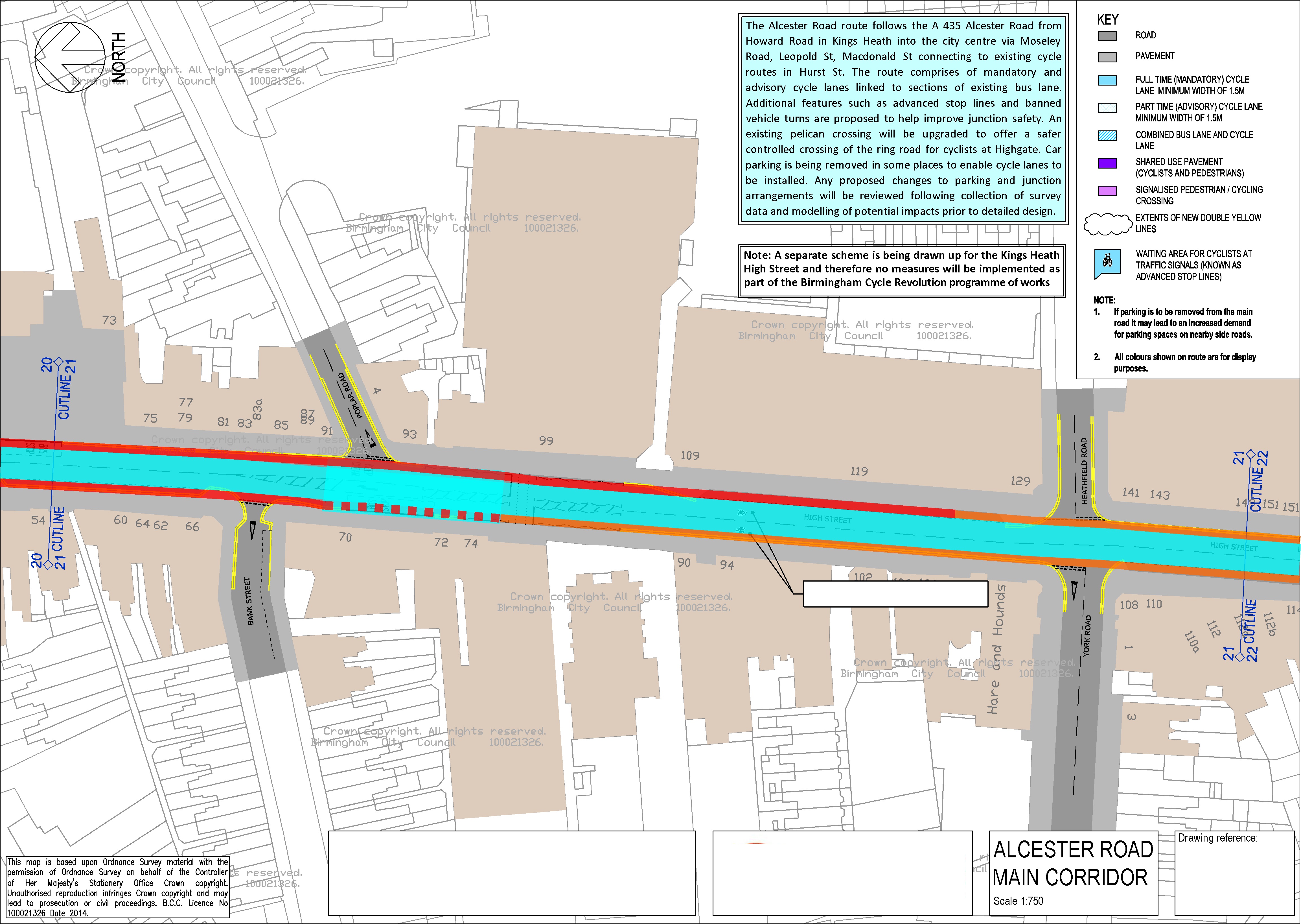
An advisory lane has been provided where (Asda) trucks need to turn into Poplar Road. Car drivers may be tempted to use this (though note the right turn pocket has been removed), but in general a car driver will follow the centre line. Given the amount of trade Asda does in Kings Heath (which experience shows cycle lanes will only increase), it is extremely unlikely they would leave the area if a reduced carriageway width forced them to use smaller trucks. Smaller trucks would also reduce the problems large articulated trucks cause in Poplar Road.
The three disabled parking bays (which are routinely abused) have been removed. There are several disabled parking bays in Kingsfield Road. Note that cycle lanes make it easier to use electric scooters, which for many disabled people not only provide door-to-door transport, but transport within shops. Additionally, the first few parking places in side streets could be made disabled parking only. Further parking could be created by prohibiting the right turn into Vicarage Road (drivers would use Howard Road), freeing up carriageway space. Alternatively the freed-up space could be used to widen the pavement.
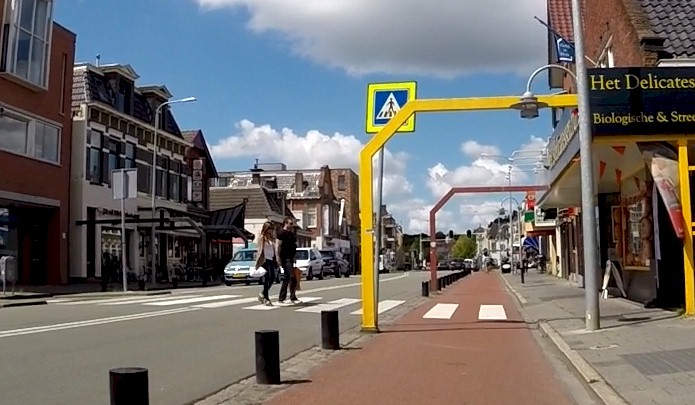
The following video shows what such an arrangement would be like in practice. It shows a high street on a radial route in the Netherlands. It has been like this since the 1980s, which shows that this proposal is based on something that has been normal in the Netherlands for many decades. Push Bikes is not proposing some wild, untested idea. Note the lack of motorised traffic. That's what happens when you achieve a cycling modal share of 60%, which is what has been achieved in this town.

